Animals Zoo Park - Amazing - Funny - Dangerous Animals

African Animals, Asian Animals, Amazing Photos, Amazing Under Water Photos Birds Photos, Flowers Pics, Free Wallpapers, Funny People Pics, Funny Pictures, Funny Videos, Hunting Videos Hunting Pics, Soccer Wallpapers, Tennis Pictures 7 Natural Wonders Information, 7 Under Water Wonders Information, 7 Wonders of the Medieval Mind, 7 Wonders of the Modern World, 7 Wonders of the Ancient World, Wonderful Temple Wallpaper, Top 10 Hollywood Stars (By visitors request), Top 10 soccer Players (By visitors request), Top 10 Tennis Players (By visitors request), 10 most Dangerous Snakes, Dangerous Animals, 10 most deadliest snakes, 10 Most Poisonous Animals in the World, all Wonders Of the World.
Showing posts with label The Seven Forgotten Natural Wonders of the World. Show all posts

Tuesday, January 26, 2010

Iguacu Falls Information Pictures

Iguacu Falls location :
The Iguaçú Falls are located in the Iguaçú National Park, at the border of Brazil and Argentina.

Iguacu Falls Information :
In a horseshoe form, 2,700 meters wide between the two countries, the Iguaçú Falls fill the visitors's view with the spray of 72 meter-high falls - the number of them varies between 150 and 300, depending on the flow of the Iguaçú River. The panorama overwhelms the onlooker with a sensation of fright, fascination and respect for the perfection of nature. A visit to the Falls and the contact with wildlife and the spectacle of the waters awake an emotion that many hope to experience once in a lifetime.

Iguacu Falls Pictures -

Saturday, January 23, 2010

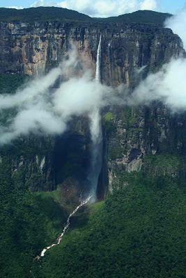
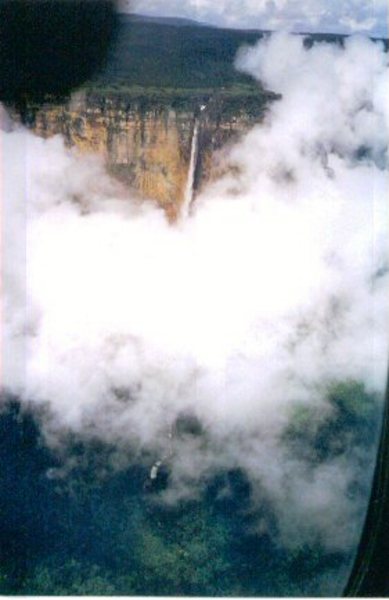
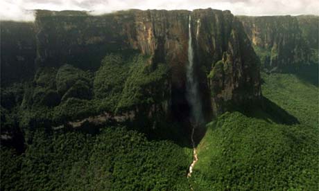
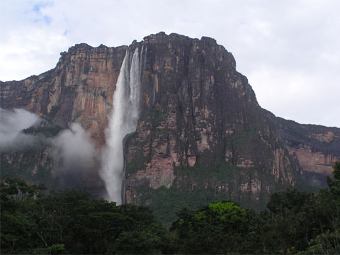
Angel Falls In Venezuela Pictures and info - Water Falls South America

Water Falls - Angel Falls In Venezuela South America Pictures :

Facts and Information Angel Falls in The Seven Forgotten Natural Wonders of the World :
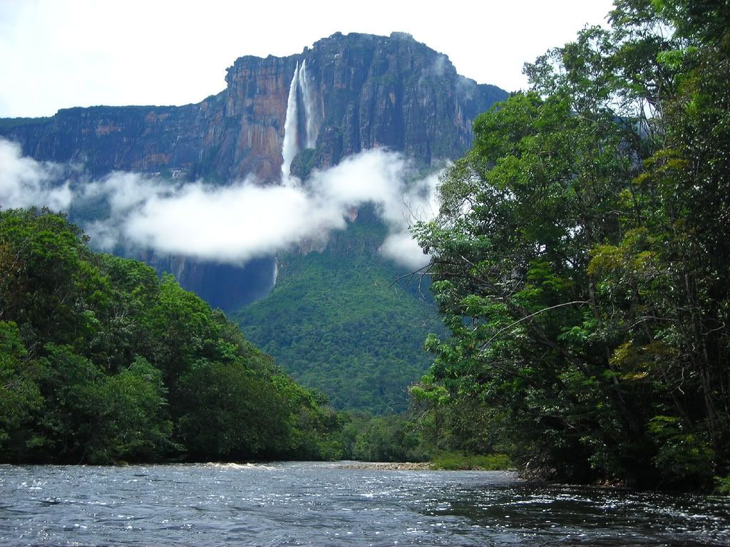
The Story of the Angel Falls Discovery : The Natives in Venezuela had known about the "Salto Angel" since the beginning of time. Then United States pilot Jimmie Angel was flying over the area in 1935 when he landed on the top of a lone mountain in search of gold. His plane got stuck in the boggy jungle on top of the mountain and he noticed a pretty impressive waterfall plunging thousands of feet down. He wasn't too happy about the 11 mile hike back to civilization, and his plane remained stuck and rusting upon the mountain as a monument to his discovery. Soon the whole world would know about the falls, which came to be known as Angel Falls, after the pilot who "discovered" them.
Angel Falls plunges from the top of a mesa, or what the natives call a Tepuyi. Named "Auyantepui", the Angel Falls mesa is one of over a hundred of its kind which are scattered about the Guiana Highlands of southeast Venezuela. Like so many slumbering giants, what characterizes these mesas (Tepuys) is their massive heights soaring up towards the sky, each with a flat top and totally vertical sides (check out the picture at left). Also called "table mountains" (which accurately describes their shapes) these Tepuys were formed out of sandstone billions of years ago. Their vertical sides are continually being eroded by the action of water from the heavy rainfall the Guiana Highlands gets. Courtesy By extremescience.com

Angel Falls Water Falls PictureAngel Falls Water Falls Picture

Angel Falls Water Fall PictureAngel Falls Water Fall Picture

Angel Falls venezuela PictureAngel Falls venezuela Picture

Angel Falls Water Fall PictureAngel Falls Water Fall Picture


Angel Falls. Buy this poster at AllPosters.com

"Where is the highest waterfall in the World?"
Hidden in a wilderness region, called the Gran Sabana, in Venezuela.

They tumble 1000 meters off the edge of an escarpment of the mysterious Auyan Tepuy, a sandstone mesa of 700 sq kms. The Angel Falls were discovered by accident in 1935 by Jimmy Angel (1899-1956), an American adventurer and bush pilot who operated in Central and South America.

> Discovery:
Last summer I made an excursion to view the Falls and learned of the exciting history of their discovery.

Jimmy Angel owned a Fokker monoplane of 1930's vintage, capable of carrying 3 passengers and freight. He became a legendary figure in Venezuela, in his quest for gold and daredevil flying.

While flying up the Devil's Canyon sector of Auyan Tepuy he spotted amongst the clouds an impressive waterfall that hurtled into space to spray the jungle below.

In 1937 he tried to land his plane on top of the flat-topped mountain close to the Falls, but ended up in a bog. He and his passengers had to abandon the plane and proceed on foot. A near vertical kilometer of cliff was descended to reach the jungle below. After 11 days of bushwhacking they reached an Indian village on a river that lead to civilization.

Fokker Monoplane
Jimmy Angel's Fokker Monoplane

Jimmy Angel's Fokker Monoplane

Jimmy Angel's plane, "El Rio Caroni", remained on the summit until 1970, when it was airlifted out and put on display at Cuidad Bolivar airport. It is in an excellent state of preservation, looking more robust than the little Cessna I flew in to Canaima.

Near midnight I booked into the Hotel Italia on the waterfront of the Orinoco River at Cuidad Bolivar, after a long, air-conditioned bus ride from Caracas.

Carlos, the manager, greeted me.
"Want to join a tour group to see the Angel Falls?" he asks, "Come and see me in the morning."
That's service for you!

> The Tour:
The tourist entry point is the isolated village of Canaima located at a beautiful spot on the Rio Carrao where a series of cataracts plunge into an extensive lagoon. This is Canaima National Park of 3 million hectares and there is no road access. The airstrip perimeter is a clutter of light planes of amazing variety. Twice a day a jet from Caracas disgorges tourists who are shuttled off to up market, air-conditioned accommodation.

spacer
Canoe on the Rio Churan

Canoe on the Rio Churan

My tour group consisted of 6 Europeans, German speaking, and a Venezuelan guide who spoke English. We boarded a motorized dugout canoe and sped across the lagoon in front of the cataracts. On the far side we hiked above Salto El Sapo, where another canoe laden with provisions was waiting to take us into the jungle.

Canoe access to the Angel Falls is restricted to the rainy season, June to November. Thanks to El Niño, the rains had continued and the river was negotiable at the end of November, but only just. Alternatively, weather permitting and with absence of cloud, you can fly by the Falls, but blink and you've missed them.

The Rio Carrao is up to 200 meters wide and leads straight to Auyan Tepuy. We donned lifejackets and huddled under canvas drapes to shelter from the spray as we roared up several scary rapids. Towards dusk we pulled into the bank at Camp Orquidea - a jungle camp beneath towering rocky bluffs.

The shelter was open-sided with a thatch roof. Sandstone floor paving stones show ancient ripple marks. Other tour groups used the camp. About 50 hammocks complete with mosquito nets awaited our tired bodies. Soon the kitchen was a hive of activity and we enjoyed spaghetti bolognaise by candle light, joined by a group of 20 Italians who raged into the night.

Next morning our canoe headed up the tributary Rio Churan to take us deep within the mountains. Rapids were more frequent and frightening. Huge sandstone blocks stud the river bed.


Finally we reached Rat Island opposite Devil's Canyon and our first glimpse of Angel Falls, an awesome plume falling from the clouds that shroud the mountain tops.

Our guide explained that an hour's hike up through the jungle will bring us to the Mirador, a rocky outcrop from where we would see the Falls in their entirety. Up, and jungle, are the operative words - a tangle of lianas, fallen branches, mossy rocks and mosquitoes made progress miserable but it was worth the struggle. The cloud cleared from the tops.

A river took off into space high above. What a sight! A tremendous amphitheatre at the base of the Falls was a swirling mass of spray.

A DC3 tourist aircraft flew by, in and out of the cloud - Wow, I thought, I'm glad to be on tierra firma and not dodging mountains!

We clambered down the rocks to the stream and bathed in the first substantial pool below the Falls. The cool mountain waters cleansed us of sweat and grime and left us invigorated for the hike back and a welcome lunch at the boat landing.

The return journey next day by canoe down the Rio Carrao was a delight. Above the rapids, we were put ashore to hike for a few kilometers while the boteros took the boat down unladen for the water level had dropped considerably. The afternoon flight to Cuidad Bolivar by Cessna taxi gave us a bird's eye view of neighbouring mesas poking up from the jungle.

Carlos, at the Hotel Italia, welcomed me back.
"You must join tomorrow's tour of the Gran Sabana by minibus." he implores.
What a salesman!

Angel Falls South AmericaAngel Falls South America

South America Water Falls PictureSouth America Water Falls Picture

venezuela Water Falls Picturevenezuela Water Falls Picture


> See the Beautiful Water Falls and Enjoy. Full Day Tour at angel-falls.com ,

On your flight to Canaima you will fly by Angel Falls, the highest waterfall in the world (3300 ft). After flying by the falls you will land at Canaima where you will find the famous waterfalls of the Canaima lagoon. From here you will cross the lagoon on a "curiara" (Indian dugout canoe) which will take you to a hiking trail where you will begin an easy hike to a waterfall called El Sapo, here you will find yourself following the trail that takes you directly behind the curtain of water of this incredible waterfall (be ready to get wet!!). After the excursion you will be offered a typical barbecue lunch (with a view of the Canaima lagoon).

> Angel Falls, Canaima National Park Ultimate Tour More Details at angel-ecotours.com


> A day tour to Angel Falls For More Details venezuelatuya.com

The Bay of Fundy Pictures and Photos

The Bay of Fundy Photo

The Bay of Fundy Picture

The Bay of Fundy

The Bay of Fundy (French: Baie de Fundy) is a bay on the Atlantic coast of North America, on the northeast end of the Gulf of Maine between the Canadian provinces of New Brunswick and Nova Scotia, with a small portion touching the U.S. state of Maine. The Bay of Fundy is known for its high tidal range and the bay is contested as having the highest vertical tidal range in the world with Ungava Bay in northern Quebec and The Severn Estuary in the UK. Some sources believe the name "Fundy" is a corruption of the French word "Fendu", meaning "split" [1], while others believe it comes from the Portuguese fondo, meaning "funnel."[2]

The bay was also named Baie Française (French Bay) by explorer/cartographer Samuel de Champlain during a 1604 expedition led by Pierre Dugua, Sieur de Monts which resulted in a failed settlement attempt on St. Croix Island.

Portions of the Bay of Fundy, Shepody Bay and Minas Basin, form one of six Canadian sites in the Western Hemisphere Shorebird Reserve Network, and is classified as a Hemespheric site.[3] It is owned by the provinces of New Brunswick and Nova Scotia, and the Canadian Wildlife Service, and is managed in conjunction with Ducks Unlimited Canada and the Nature Conservancy of Canada. Read More at wikipedia

Sunday, January 17, 2010

Niagara Falls Wallpapers and Pictures -The Seven Forgotten Natural Wonders of the World Information

The Seven Forgotten Natural Wonders of the World : Niagara Falls Wallpapers and Pictures with Info.

Niagara Falls at Night PictureNiagara Falls at Night Picture

Niagara Falls WallpaperNiagara Falls Wallpaper

Niagara Falls WallpaperNiagara Falls Wallpaper

Niagara Falls PictureNiagara Falls Picture


> The Niagara Falls are voluminous waterfalls on the Niagara River, straddling the international border between the Canadian province of Ontario and the U.S. state of New York. The falls are 17 miles (27 km) north-northwest of Buffalo, New York and 75 miles (120 km) south-southeast of Toronto, Ontario, between the twin cities of Niagara Falls, Ontario, and Niagara Falls, New York.

Niagara Falls is composed of two major sections separated by Goat Island: Horseshoe Falls, the majority of which lies on the Canadian side of the border, and American Falls on the American side. The smaller Bridal Veil Falls are also located on the American side, separated from the main falls by Luna Island.

Niagara Falls were formed when glaciers receded at the end of the Wisconsin glaciation (the last ice age), and water from the newly-formed Great Lakes carved a path through the Niagara Escarpment en route to the Atlantic Ocean. While not exceptionally high, the Niagara Falls are very wide. More than six million cubic feet (168,000 m³) of water falls over the crest line every minute in high flow, and almost 4 million cubic feet (110,000 m³) on average. It is the most powerful waterfall in North America.

The Niagara Falls are renowned both for their beauty and as a valuable source of hydroelectric power. Managing the balance between recreational, commercial, and industrial uses has been a challenge for the stewards of the falls since the 1800s.

> Characteristics : Niagara Falls is divided into the Horseshoe Falls and the American Falls. The Horseshoe Falls drop about 173 feet (53 m), the height of the American Falls varies between 70-100 feet (21 m) because of the presence of giant boulders at its base. The larger Horseshoe Falls are about 2,600 feet (792 m) wide, while the American Falls are 1,060 feet (323 m) wide.
The volume of water approaching the falls during peak flow season may sometimes be as much as 202,000 cubic feet per second (5,720 m³/s). Since the flow is a direct function of the Lake Erie water elevation, it typically peaks in late spring or early summer. During the summer months, 100,000 cubic feet per second (2,832 m³/s) of water actually traverses the Falls, some 90% of which goes over the Horseshoe Falls, while the balance is diverted to hydroelectric facilities. This is accomplished by employing a weir with movable gates upstream from the Horseshoe Falls. The Falls flow is further halved at night, and during the low tourist season in the winter, remains a flat 50,000 cubic feet per second (1,416 m³/s). Water diversion is regulated by the 1950 Niagara Treaty and is administered by the International Niagara Board of Control (IJC).

Viewpoints on the American shore generally are astride or behind the falls. The falls face directly toward the Canadian shore.


> The Future of Niagara Falls :

The future of Niagara Falls is not easily predicted. The Falls of Niagara as we know it today will remain as it is for thousands of years to come.

Erosion is the largest factor which will alter its appearance in the future. Some have estimated that the Falls would continue eroding southward for the next 8,000 years at which time it would reach the limits of Lake Erie.

The eastern seaboard of North American is today still rising from the glacial rebound effect. It has been suggested that as the land rises on the eastern seaboard that water flow to the ocean will slow and reverse so that in the future the Falls would be much diminished or cease to exist entirely.

Perhaps the most realistic outlook is that the Falls will continue to erode southward. There is no doubt that at some point in its future that the main Horseshoe Falls once it has eroded far enough south, will cut off the water flow to the American Falls. The Falls of Niagara will once again become one.

The greatest threat to the integrity of the Horseshoe Falls and the American Falls is rock falls. The American Falls has been the victim of many rock falls in the past. As the rock talus collects at the base, it reduces the distance of the water fall and creates more of a cascade effect.

In the future substantial rock falls may affect the appearance and change the Falls of Niagara to mere water cascades and/or rapids.

Mount Kilimanjaro Pictures and Location Information

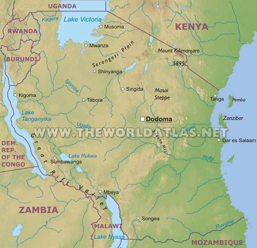
The Seven Forgotten Natural Wonders of the World : Mount Kilimanjaro Pictures and Location Information with Map.

Great African Rift Valley, created by tremendous tectonic forces which also gave birth to a string of other volcanoes. One of these, Mount Kenya, was originally much higher than Kilimanjaro.

The three summits of Mount Kilimanjaro, Shira, Kibo and Mawenzi are all of very recent origin. Shira and Mawenzi both have suffered considerable erosion and only jagged peaks remain. Kibo, the central, youngest and highest peak has survived as an almost perfect cone.

Although East Africa and nearby Olduvai Gorge is thought to be the cradle of mankind it is unlikely that early man would have been attracted to the steep and cold slopes of Kilimanjaro at a time when it was probably very active and dangerous. A Wachagga legend talks of Mawenzi receiving fire for its pipe from his younger brother Kibo. The Wachagga who live on the fertile volcanic soils around the base of the mountain probably only came to the area about 300 years ago thus this legend suggests very recent activity. Another of their legends talks of demons and evil spirits living on the mountain and guarding immense treasures. Stories are told of a king who decided to go to the top, few of his party survived and those who did had damaged arms and legs.

Arab and Chinese traders and historians make mention of a giant mountain lying inland from Mombasa or Zanzibar but few early traders ventured into the interior of the continent. Slave traders passed below it and sometimes raided the villages of the Wachagga but it was not till the middle of the 19th century that a more serious interest was taken in the mountain and attempts were made to scale it.

In 1848 Johann Rebmann a missionary from Gerlingen in Germany while crossing the plains of Tsavo saw Mount Kilimanjaro. His guide talked of baridi - cold, and of tales how a group of porters were sent up the mountain to bring back the silver or other treasures from the summit.They came back only with water. Rebmann's report stimulated great interest in Germany and in the following years several expeditions were organised; first by Baron von Decken then later by Dr. Hans Meyer who finally stood on the highest point on the 5th of October 1889.


Mount Kilimanjaro PictureMount Kilimanjaro Picture

Mount KilimanjaroMount Kilimanjaro Picture

Mount Kilimanjaro Africa PicsMount Kilimanjaro Africa Pics

Root Map PicsRoot Map Pics

Map Location to reach RootMap Location to reach Root

Location Map PhotoLocation Map Photo

Mount Fuji Japan Pictures and Wallpapers

Mount Fuji WallpaperMount Fuji Wallpaper
Mount Fuji Japan PictureMount Fuji Japan Picture

Mount Fuji Japan PictureMount Fuji Japan Picture

Mount Fuji Japan WallpaperMount Fuji Japan Wallpaper

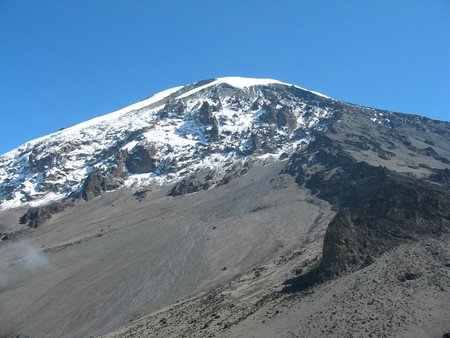
Mount Fuji is japans tallest mountain. Towering at 3776 meters high. It is shaped perfectly as a dormant volcano. Mount Fuji erupted in 1708. It is a beautiful geographic sight. This wicked mountain inspires many artists. Although you need a very clear day to see the mountain in this perfect view. It’s often very cloudy.